Two often confusing data points broken down for your convenience.
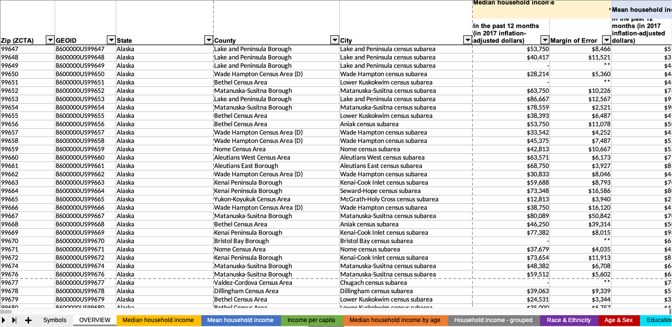
Let’s say you’re a customer of Censtats. You open up the XLSX and you see how your file is formatted: ZCTA, GEOID, State, County, City, and so on. Pretty simple, right?
But inevitably you’ll come across some oddities under the “City” column. The oddities I’m talking about are some you might’ve noticed already: division, precinct, UT, and subarea. Those aren’t city names you’re familiar with, are they? There’s a reason for that.
In order to ensure the data they collect is the highest quality and the most accurate, the Census Bureau often has to make adjustments to the traditional boundaries that cities are made up of. We’ve already seen examples of this with ZCTAs, but the subjects of this post go a step further. MCDs, CCDs, UTs, and subareas don’t mean anything right now, but they are important in understanding some of the most glaring quirks you can find in our XLSX. These quirks come up in a lot of places, but the most common traits you’ll find are places where counties don’t exist (Alaska), where total area and population spread make projections difficult (ex. Mississippi), and where large amounts of used land adjoins a city (ex. South Dakota)
So let’s run down these terms so that our XLSX makes a bit more sense!
Minor civil divisions (MCDs) are where we start. These are subdivisions the Census Bureau uses to collect information that are primarily based around state defined borders. This includes cities, towns, townships, and so forth, and are legally defined by the states.
Census county divisions (CCDs) come into play when the Census Bureau deems a state to have unsatisfactory MCDs for data collection or where there aren’t many MCDs to begin with. This comes about by unorganized division of land (counties with minuscule populations therefore equaling unimportant data) or lack of local governments that could serve as the basis or reference for statistical boundaries. CCDs were then created in collaboration between the Bureau and state and local governments.
Ultimately, remember this: MCDs are legally defined; CCDs are statistically defined.
An important note about MCDs and CCDs is that one state cannot have both. What this means is that in a state that uses MCDs, there are going to be large parts of land that are unincorporated, like farmlands, that still have to be accounted for. These are called unorganized territories (UTs). For example, take a look at Yankton, SD:
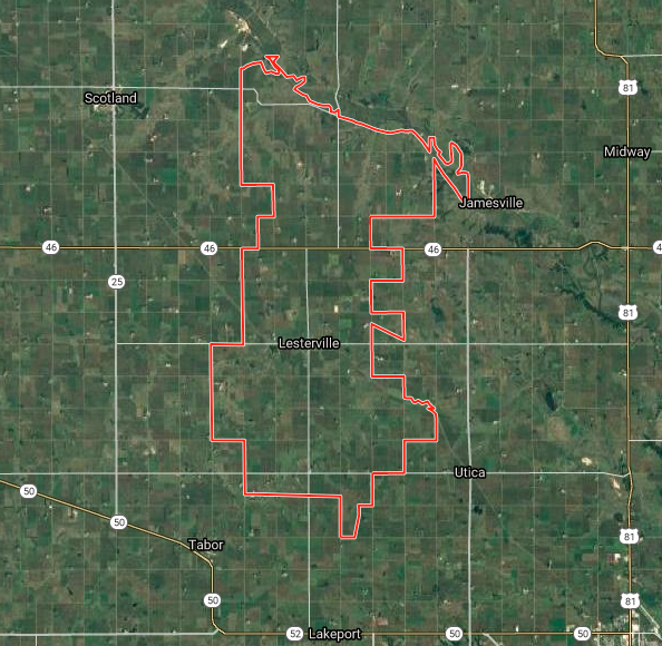
This ZCTA (57040) includes farmland west of Yankton, which is why you’ll find it in the XLSX listed as “West Yankton UT”:

Census subareas (CSAs) are found exclusively in Alaska because the state lacks counties and MCDs, and are a combination of legal entities called boroughs and statistical entities called census areas.
If you’re wondering why Alaska doesn’t have counties, it’s pretty simple: The state doesn’t have the population required to support the government entities that equal counties.
Hopefully this clears up any confusion that may arise from browsing our XLSX, but if anything remains unanswered: Ask us! We’re more than happy to answer any questions about the Census and Censtats.
Header image sourced with permission from alexander7david.
This September marks the third annual campaign to raise disaster readiness and response education
A look at the Census Bureau's newest developments on the next decennial census